


CHCNAV AlphaAir 15 Airborne LiDAR System for UAV & Aerial Mapping
CHCNAV AlphaAir 15 (AA15) - Premium Airborne LiDAR Scanner
Unmatched Versatility, Precision, and Performance
The CHCNAV AlphaAir 15 (AA15) is a state-of-the-art airborne LiDAR scanner designed for high-accuracy, long-range data collection in a lightweight and compact form. It can be mounted on a UAV (CHCNAV X500), helicopter, or light aircraft. The AA15 is made for big missions, making it perfect for professionals working on complex mapping projects on a large scale.
Superior Productivity & Efficiency
✔ Ultra-High Point Density – Captures up to 2 million points per second. This ensures precise 3D reconstructions of power lines, highways, railways, and pipelines.
✔ Extended Scanning Range – With a maximum range of 1,800 meters, the AA15 effectively maps large areas, from cities to remote mountain regions.
✔ Exceptional Accuracy in Rugged Terrain – Maintains exact precision even in valleys and challenging elevation changes. This makes it essential for demanding survey missions.
Why Choose the CHCNAV AA15?
Ultra-Lightweight Yet Powerful – It is the lightest LiDAR system in its class, easily integrating with UAVs for efficient aerial mapping or scaling up to helicopters for large-area surveys.
Versatile Across Applications – It performs well in urban mapping, corridor mapping, forestry surveys, and infrastructure inspections.
Industry-Leading Data Quality – Produces high-density point clouds with clear detail, ensuring accurate feature extraction and modeling.
Elevate your airborne surveying with the CHCNAV AlphaAir 15 (AA15). It is the top choice for professionals who need high-precision LiDAR solutions in any environment and on any platform.
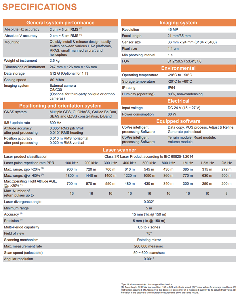
Technical Specification
Alpha Air 15
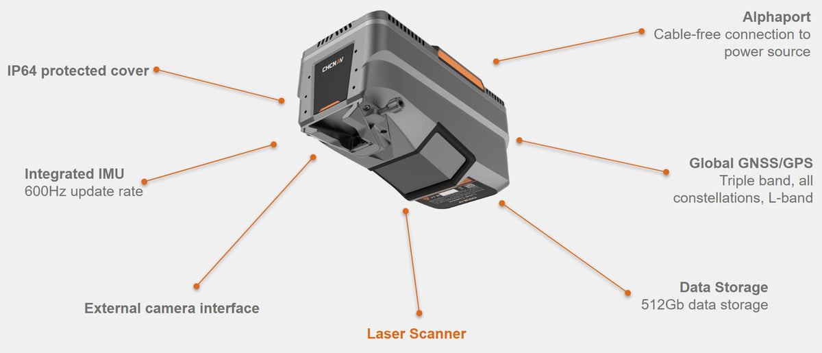
AlphaAir 15 features
Premium airborne LiDAR

Lightweight Power for Long-Range Precision
Weighing just 2.5 kg, the AlphaAir 15 (AA15) is the lightest LiDAR in its class — built for UAVs, helicopters, and small manned aircraft. With a scanning range of up to 1800 meters and 2 million points per second, the AA15 delivers highly accurate, high-density point clouds in mountainous terrain, vegetation, and urban environments. Its ability to capture up to 16 returns per pulse ensures exceptional ground detection and canopy penetration, even in the most densely forested areas.

CoPre: Precision Processing, Simplified
The AA15 comes bundled with CHCNAV’s CoPre software — CoPre delivers robust trajectory processing, advanced strip-adjustment, and automated point‑cloud colorization—all in a single, intuitive ecosystem. Built-in quality checks ensure dependable data integrity every time

Two Systems, One Canopy: Precision Forestry with AA15 & RS10 (TrueView Go)
The AA15 UAV captures dense, high-resolution point cloud data from above, efficiently scanning vast forest areas in a single flight. Paired with the handheld SLAM RS10 (TrueView Go), which fills in gaps and captures under-canopy details, this hybrid approach ensures complete, precise, and actionable forestry datasets. Together, they enable accurate tree height, crown width, and DBH (diameter at breast height) measurements—unlocking the full potential of modern forest analysis.


High-Performance Aerial LiDAR Without the High Price
The AlphaAir 15 (AA15) is the smart choice for professionals seeking a high-performance aerial LiDAR system that delivers exceptional accuracy, range, and efficiency—without breaking the budget. With everything included in one streamlined package—scanner, GNSS, IMU, camera support, and CoPre processing software—you get a complete solution ready to fly. Whether you're mapping forests, infrastructure, or challenging terrain, the AA15 offers the capabilities of premium systems at a far more accessible cost.
LiDAR AlphaAir 15
Premium Airborne Lidar Solution


Powerline Mapping by Air: AA15 in Mountainous Terrain
Deployed on a fixed-wing aircraft, the CHCNAV AlphaAir 15 (AA15) demonstrated its full potential by capturing powerline corridors across rugged, mountainous terrain.
With an ultra-light 2.5 kg design, 1800 m range, and 16 return echoes, the AA15 accurately recorded fine details — including transmission wires, towers, terrain contours, and vegetation clearance — in a single high-speed flight.
The result is a dense, survey-grade point cloud ideal for line inspection, clearance analysis, and topographic modeling — even in the most inaccessible regions.
Note. To explore the dataset in detail: Double-click to zoom in; Use the scroll wheel to zoom in/out; Right-click and drag to pan across the scene;