


CHCNAV AlphaUni 20 Multi-Platform Mobile Mapping LiDAR System
CHCNAV AlphaUni 20 (AU20) – High-end Professional Multi-Platform LiDAR Scanner
Seamless Integration Across Air and Land
The CHCNAV AlphaUni 20 (AU20) is a premium multi-platform LiDAR system built for unmatched flexibility and accuracy. Whether mounted on a UAV, helicopter, fixed-wing aircraft, car, boat, or even a backpack, the AU20 easily adapts to any survey scenario, delivering high-density, high-precision point cloud data with ease.
Unmatched Multi-Platform Versatility
- Aerial - Mounts to UAVs, helicopters, or fixed-wing aircraft for large-scale terrain mapping and corridor surveys.
- Ground- Easily mounts to cars, trucks, boats, or trains for mobile mapping of roads, railroads, and coastlines.
- Pedestrian mobility – use as a backpack system for detailed surveys of urban or hard-to-reach areas.
- Rapid deployment – quickly switch between platforms for maximum efficiency across multiple projects.
Key Benefits:
✔ Highly accurate mapping – achieves 2-5cm accuracy in a variety of environments, from dense forests to urban landscapes.
✔ Extreme data density – captures up to 2 million points per second, delivering superior detail for infrastructure, utilities, and environmental monitoring.
✔ Advanced terrain adaptability – handles complex terrain and vegetation with up to 16 target echoes for deeper ground penetration.
✔ Lightweight and rugged – compact, rugged, and built for challenging conditions, making it ideal for professionals on the go.
The CHCNAV AU20 is the best choice for surveyors and geospatial information professionals who require a high-performance, all-weather LiDAR solution that works seamlessly on air, land and marine platforms.
CHCNAV AlphaUni 20 Multi-Platform Mobile Mapping LiDAR System is backordered and will ship as soon as it is back in stock.
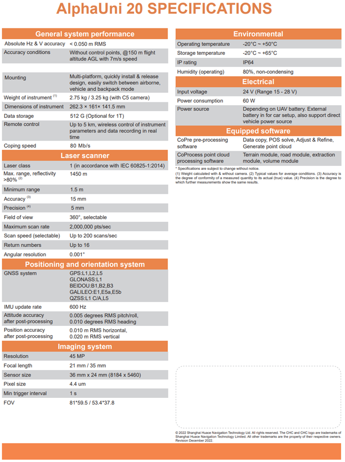
Technical Specification
Alpha Uni 20
AlphaUni 20 features
Multi-platform high-end LiDAR solution for mapping and geospatial
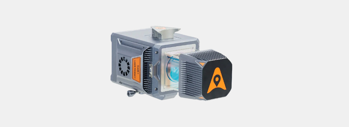
AlphaUni 20 LiDAR
A cost-effective and multi-platform mobile mapping system


Urban Mapping in Motion: AU20 Vehicle-Mounted LiDAR
Captured using the CHCNAV AlphaUni 20 (AU20) mounted on a vehicle, this dataset highlights the system’s ability to scan dense city environments with exceptional detail and speed. From road surfaces and curbs to facades, signage, and vegetation, the AU20 delivers survey-grade accuracy across every frame — ideal for urban planning, infrastructure maintenance, and 3D city modeling.
Note. To explore the dataset in detail: Double-click to zoom in; Use the scroll wheel to zoom in/out; Right-click and drag to pan across the scene;