


CHCNAV TX73 3D Excavator Machine Control System
CHCNAV TX73 3D Machine Guidance for Excavators
Advanced Precision and Efficiency with the CHCNAV TX73 Excavator Guidance System
The CHCNAV TX73 excavator guidance system is an advanced 3D machine control solution designed to enhance excavation efficiency, accuracy, and workflow optimization. With state-of-the-art GNSS receivers, rugged IMU sensors, and real-time 3D visualization, the TX73 enables operators to complete excavation tasks faster and with higher precision. The MCNAV software provides an intuitive user interface, seamless remote connectivity, and easy calibration for optimal project execution.
Key Features and Benefits
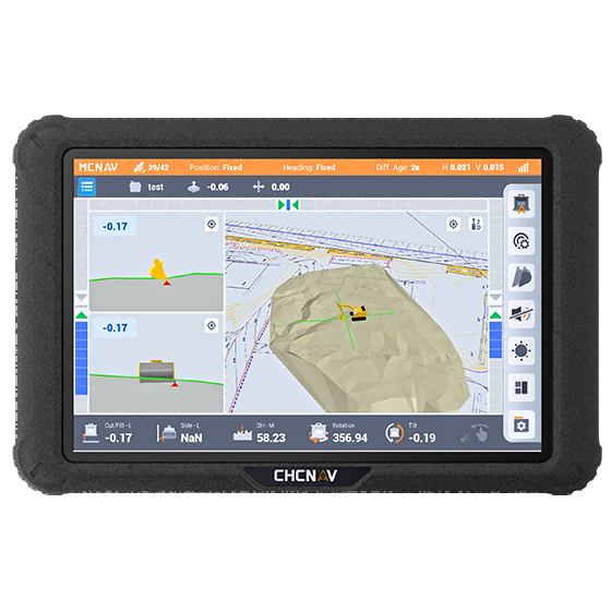
1. High-Precision 3D Guidance
- Dual GNSS and IMU Integration: Provides real-time tip position tracking, ensuring excavation is completed to the correct design specifications.
- Dynamic Accuracy: With a precision of ±0.1° (dynamic) and ±0.05° (static), the system ensures high accuracy on both sides of the bucket.
- Real-Time 3D Visualization: Includes high-fidelity CAD drawings with multiple viewing angles (3D, top, and side views) to support accurate excavation.
2. Easy to Use and Fast Setup
- Quick Calibration: A simple wizard-based calibration allows for fast setup with minimal downtime.
- Instant Start-Up: The system is designed for plug-and-play operation, reducing learning curves for operators.
- Remote Access and Cloud Support: Through the iSite cloud platform, users can remotely troubleshoot, synchronize data, and distribute files.
3. Superior Compatibility and Customization
- Versatile Machine Support: Compatible with all excavator models and various bucket types, including standard, tilt, tiltrotator, and trapezoidal buckets.
- Seamless Integration with RTK and Radios: Supports Satel external radios and protocols such as TT450S, Transparent, and Satel_3AS.
- Multiple Coordinate and Design File Support: Works with .LandXML, .DWG, .DXF, .HCTX formats and supports built-in global coordinate systems.
4. Rugged and Reliable Hardware
- Industrial-Grade Protection: The MC300 receiver and IS300 IMU sensor are designed for extreme durability.
-
Waterproof and Shockproof:
- MC300 Receiver: IP67-rated for high reliability.
- IS300 IMU Sensor: IP69K-rated with a shock resistance of 50G.
- GNSS Antenna: IP68-rated with a metal shell to prevent interference.
- High-Performance Display: The 10.1" widescreen (1920x1200) provides customizable interfaces with color-coded progress maps.
Why Choose the CHCNAV TX73?
The CHCNAV TX73 is a high-performance 3D machine control system that enhances excavation efficiency by providing real-time accurate positioning, intuitive controls, and a ruggedized design. With full 3D CAD integration, remote connectivity, and high GNSS accuracy, it ensures precise excavation with reduced labor and material costs.
Operators can quickly design surfaces in the field, switch between 2D and 3D modes, and rely on stable GNSS positioning even in difficult conditions. Whether working on urban infrastructure, large-scale earthworks, or specialized excavation projects, the TX73 is the perfect investment for increasing productivity and minimizing operational errors.
Diagram
TX73 3D Machine Guidance for Excavators

The TX73 features
High Accuracy 3D excavator guidance system
TX73 Excavator Guidance System
High Accuracy, Easy to use, Excellent Compatibility

