High payload & endurance
5 kg max payload and up to 58 minutes aloft (50 min with the CHCNAV AA10 LiDAR) — enough to map far more ground per battery than lighter consumer-class platforms.


The CHCNAV X500 is a high-performance multirotor platform built for surveyors, mapping teams, and inspection crews who need real payload capacity and endurance in the field. It carries up to 5 kg, stays airborne up to 58 minutes, and transmits HD video out to 20 km — enough to cover serious ground in a single sortie. With dual-redundant flight control, high-precision positioning, and an open payload bay, it's a dependable workhorse for pipeline and corridor mapping, mining surveys, forestry, volumetric work, power-line inspection, and construction.
Unlike consumer-derived survey drones that lock you into a closed ecosystem, the X500 runs on the open MAVLink protocol with an SDK payload interface — so you fit the LiDAR or camera your project actually calls for, not whatever the manufacturer allows.
Technical Specification and Features
CHCNAV X500 UAV
High-Performance Rotor UAV · Sold & supported in Canada
A professional-grade multirotor platform delivering a 5 kg payload, up to 58 minutes of flight, and a 20 km transmission range — engineered with triple-redundant IMUs, dual-redundant GNSS and flight control, millimeter-wave obstacle avoidance, and triple-rotor spin protection. Where consumer-derived survey drones lock you into a closed ecosystem, the X500 stays open: MAVLink protocol, an SDK payload interface, and hot-swappable smart batteries.
 Click to enlarge
The CHCNAV X500 pairs advanced flight control and high-precision positioning with built-in Visual SLAM and obstacle-detection radar — for intelligent, dependable operations in demanding environments. Compatible with CHCNAV LiDAR and camera payloads plus SDK-certified third-party sensors, it adapts to corridor mapping, urban surveillance, disaster relief, stockpile volumes, power-line and wind-turbine inspection, and more.
 Click to enlarge
Everything that matters for professional aerial mapping — performance, safety, energy, and payload flexibility — in one platform.
5 kg max payload and up to 58 minutes aloft (50 min with the CHCNAV AA10 LiDAR) — enough to map far more ground per battery than lighter consumer-class platforms.
3× IMU and 2× GNSS units with seamless failover, plus a dual-redundant flight control system with automatic master/slave switching.
Millimeter-wave radar detects obstacles to 80 m in any light — trees, buildings, and towers — backed by a 1080p FPV camera with electronic stabilization.
Vision-based positioning enables guided landings on moving vehicles and vessels — a capability rarely offered out of the box.
Next-generation industry video link delivers stable, low-latency HD over long distances — expanding BVLOS mission areas without dead zones.
Single/dual downward and upward mounts carry up to three sensors at once, with an open SDK for SDK-certified third-party devices.
Stable & safe flight
Safety isn't a checkbox on the X500 — it's the architecture. Triple-redundant IMUs and dual-redundant GNSS keep positioning honest; if a unit fails mid-flight, the system switches seamlessly to maintain reliability and precision. Two independent flight-control units run in master/slave, and multiple safe-return strategies — intelligent return, low-battery return, lost-connection return, and obstacle-avoidance return — protect your aircraft from launch to landing.
*Triple-rotor protection reduces crash damage but cannot guarantee crash avoidance; effectiveness varies with payload and conditions.
 Click to enlarge
Dual Li-Po batteries, dual flight control, triple IMU, transmission and GNSS antennas, obstacle radar, TOF and Visual SLAM, quick-release shock-absorbing payload mount, and night-flight indicators.
 Click to enlarge
 Click to enlarge
High-efficiency energy system
The X500 runs on two B10 intelligent batteries (470.4 Wh, 10,000 mAh each) that hot-swap — pull one, drop in a charged pack, and keep flying without a full power-down. Rated for 450 cycles with capacity holding above 80%, they lower your true cost per flight.
The BS10 station stores six batteries, charges two at a time from 20% to 90% in about 40 minutes (220 V), runs three intelligent charge modes, and can act as a field power bank when you need it.
SmartGo — one app, plan to deliverable
SmartGo is CHCNAV's all-in-one ground control software — you plan the mission, fly it, and manage the payload from a single screen. Every CHCNAV sensor is natively integrated, so the aircraft, camera, and LiDAR parameters (speed, altitude, overlap, resolution, point density) are configured together with no third-party glue and no calibration guesswork. Draw a polygon on the map, pick rectangular, strip, polygonal, or vertical/facade routes, and it auto-generates an efficient flight path.
Terrain-following (online or custom DSM), KML import, virtual fence, one-click takeoff/landing, resume-from-breakpoint, and live obstacle awareness keep BVLOS work simple and safe. The 1080p FPV feed streams up to 20 km over CHCNAV's low-latency HD video link to a 10.1" 1,000-nit touchscreen you can read in full sun.
 Click to enlarge
 Click to enlarge
A carbon-fiber and titanium-alloy airframe, validated through hundreds of power-simulation tests, gives the X500 its strength-to-weight edge. It's IP55 rated, holds Level 6 (12 m/s) wind resistance, operates from −20 °C to +50 °C, and reaches a 7,000 m service ceiling.
CHCNAV verified it in −35 °C cold-soak trials and +50 °C heat testing — reassurance that matters when your season runs from a Prairie winter to a midsummer site survey. Sold, supported, trained, and warrantied in Canada by Latnet Technologies Ltd. in Calgary.
Carry up to three payloads at once and integrate CHCNAV sensors or SDK-certified third-party devices. The open MAVLink architecture is what lets the X500 grow with your business instead of boxing it in.
AA6, AA6D, AA9, AA10, AA15 and AU20 LiDAR for survey-grade 3D point clouds and corridor mapping.
C5 camera, C30 oblique, and the high-resolution R6M 61 MP for orthomosaics, oblique 3D models, and DTM capture.
Dual/triple-sensor gimbals for power lines, wind turbines, and hazardous assets — no shutdown required.
Spotlights, speakers, and droppers for emergency reconnaissance and disaster relief.
High payload, long endurance, and survey-grade LiDAR make the X500 a fit for the workflows in highest demand across energy, resources, and land development.
Long-endurance LiDAR runs along oil, gas, and utility corridors with terrain-following routes — capturing kilometres of right-of-way per flight for clearance, encroachment, and as-built analysis.
Fast, repeatable stockpile and cut/fill volume calculations over large sites — accurate volumetrics for aggregates, waste, and material management without closing the yard.
Open-pit geodetic survey, bench and slope monitoring, and haul-road mapping — survey-grade point clouds for safe, current site models without putting crews on unstable ground.
Canopy and terrain mapping, tree cadastre, and biomass surveys — LiDAR penetrates vegetation to deliver bare-earth DTMs across large, hard-to-access forest blocks.
Overhead lines, towers, and wind turbines inspected without shutdowns — high-accuracy redundant data for thermal, RGB, and LiDAR analysis of hazardous assets.
Topographic survey, 3D object models, natural-surface and DTM capture, and BIM progress management for sites and development planning.
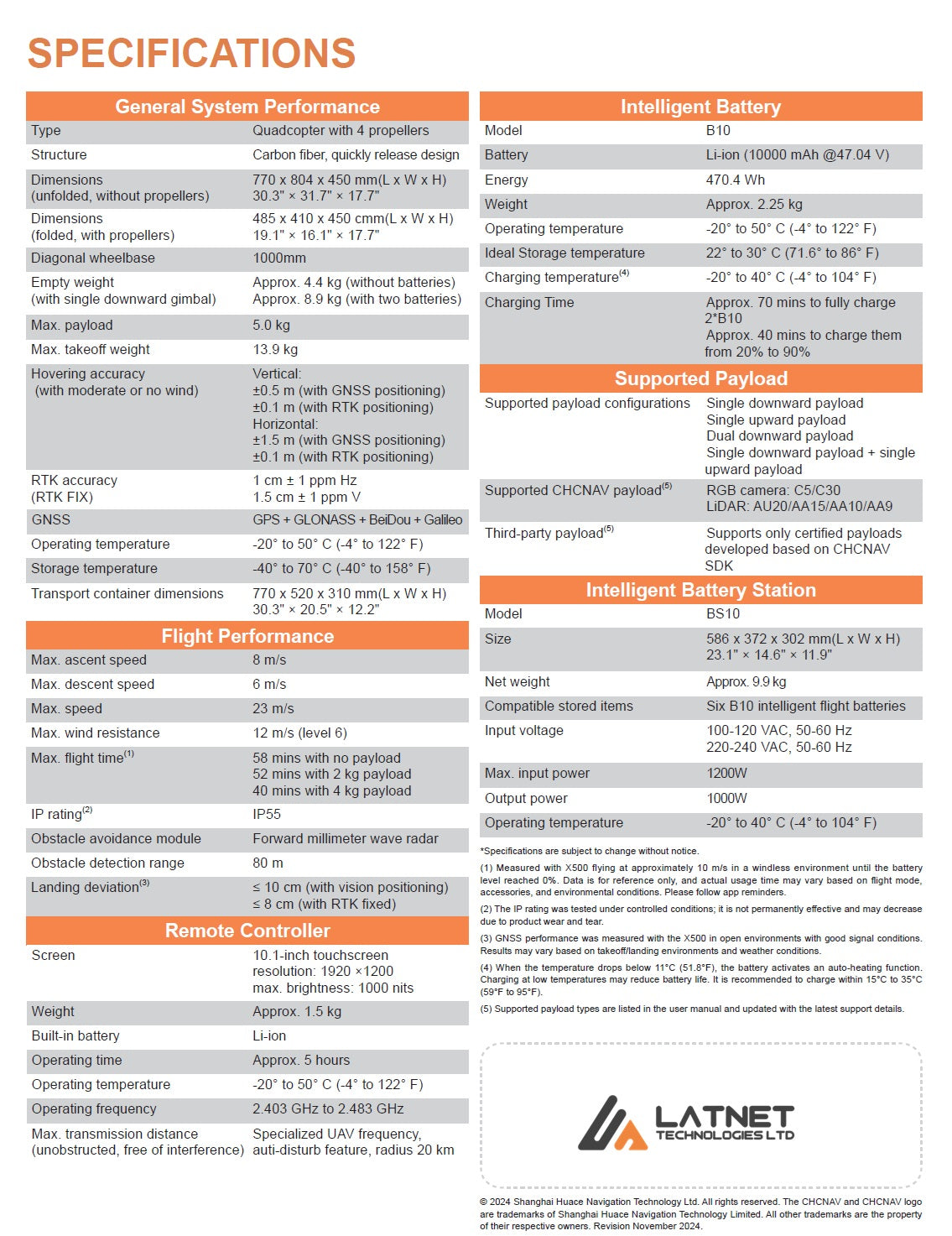
| Aircraft | |
|---|---|
| Type / structure | Quadcopter, 4 propellers · carbon fiber, quick-release design |
| Diagonal wheelbase | 1,000 mm |
| Dimensions (folded, w/ props) | 485 × 410 × 450 mm |
| Dimensions (unfolded, no props) | 770 × 804 × 450 mm |
| Empty weight | ~4.4 kg (no batteries) · ~8.9 kg (with two batteries) |
| Max. takeoff weight | 13.9 kg |
| Max. payload | 5.0 kg |
| Hovering accuracy (RTK) | ±0.1 m vertical · ±0.1 m horizontal |
| RTK accuracy (FIX) | 1 cm + 1 ppm H · 1.5 cm + 1 ppm V |
| GNSS | GPS + GLONASS + BeiDou + Galileo |
| Operating temperature | −20 °C to 50 °C |
| Flight performance | |
| Max. flight time | 58 min (no payload) · 52 min (2 kg) · 40 min (4 kg) · 50 min (AA10) |
| Max. speed | 23 m/s |
| Max. ascent / descent | 8 m/s / 6 m/s |
| Max. wind resistance | 12 m/s (Level 6) |
| Max. flight altitude | 7,000 m (high-altitude propellers above 3,500 m) |
| IP rating | IP55 |
| Obstacle avoidance | Forward millimeter-wave radar · 80 m detection range |
| Landing deviation | ≤ 10 cm (vision) · ≤ 8 cm (RTK fixed) |
| Battery — B10 intelligent battery | |
| Cell / energy | Li-ion 10,000 mAh @ 47.04 V · 470.4 Wh |
| Weight | ~2.25 kg each |
| Charging | ~70 min to fully charge 2× B10 · ~40 min 20%→90% (220 V) · hot-swap |
| Cycle life | 450 cycles, capacity above 80% |
| BS10 intelligent battery station | |
| Capacity / charging | Stores 6 batteries · charges 2 at once · 3 charge modes · power-bank output |
| Size / weight | 586 × 372 × 302 mm · ~9.9 kg |
| EC10 remote controller | |
| Screen | 10.1" touchscreen · 1920 × 1200 · 1,000 nits |
| Operating time / weight | ~5 hours · ~1.5 kg |
| Max. transmission distance | Up to 20 km (unobstructed, interference-free) |
| Payloads & software | |
| Configurations | Single downward · single upward · dual downward · single down + single up (max 3) |
| CHCNAV payloads | LiDAR: AA6 / AA6D / AA9 / AA10 / AA15 / AU20 · Imaging: C5, C30 oblique, R6M 61 MP |
| Third-party | SDK-certified payloads via open SDK · MAVLink protocol |
| Ground software | SmartGo — terrain follow, KML import, virtual fence, resume-from-breakpoint |
| Transport container | IP67 wheeled case · 770 × 520 × 310 mm · ~10.2 kg empty |
Download the X500 datasheet (PDF)
Specifications are subject to change without notice. IP rating tested under controlled conditions and may degrade with wear. Flight times measured in windless conditions and vary with payload, weather, and altitude.
Book a live demo, request a quote, or ask about rent-to-own and Canadian support, training, and warranty from Latnet Technologies in Calgary.
Book a demo or request a quoteX500 high-end unmanned aircraft system


