CHCNAV CoProcess LiDAR Processing Software
CHCNAV CoProcess - Advanced LiDAR Data Processing Software
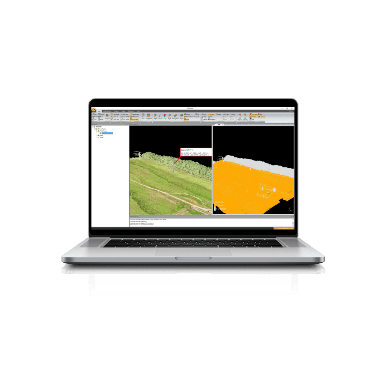
Product Overview: CoProcess by CHCNAV is an advanced software solution designed for the efficient post-processing of massive point cloud data. It transforms field-captured point cloud data into various multi-format deliverables through seamless processing. CoProcess offers powerful point cloud management, measurement tools, visualization capabilities, and a host of other features including Digital Elevation Models (DEMs), Digital Terrain Models (DTMs), semi-automatic feature extraction, and road design.
Key Features:
Powerful Feature Extraction
- Automatic and Manual Extraction: CoProcess supports robust feature extraction modules for road features, which can be converted to DAT or DXF formats for easy integration with AutoCAD and ArcGIS. This significantly improves productivity compared to traditional survey methods.
Massive Data Classification
- State-of-the-Art Algorithms: Both automatic and manual classification of point cloud data into categories such as ground, vegetation, buildings, roads, and power lines are made easy with CHCNAV’s advanced algorithms.
Volume Calculation and Analysis
- Grid Method: Supports volume calculations from point clouds, with results exportable in DXF format. Facilitates analysis of volume differences between successive LiDAR data sets, providing detailed reports for informed decision-making.
Automatic DEM/DSM Generation
- Comprehensive Processing: Generates DEMs or DSMs from point cloud data with a specialized algorithm for noise filtering and ground point filtering, ensuring high-quality data. CoProcess also offers various editing functions to enhance DEM/DSM data quality.
User-Friendly Interface Design
- Intuitive Modules: Features a customizable interface with four main modules: Foundation, Terrain, Road, and Volume. The CoData point cloud format enhances user experience when importing and visualizing large datasets, with integrated workflow wizards and user manuals for ease of use.
Advanced Point Cloud Software
- Efficient Processing: Built on significant expertise in mobile mapping data collection, CoProcess ensures high efficiency with automated point cloud processing, image georeferencing, point cloud colorization, depth maps, and results output in a single click.
Comprehensive Pre-Processing Workflow
- Trajectory Generation: Powered by accurate CHCNAV algorithms, CoProcess handles trajectory (POS) files, LiDAR data, and RGB images, allowing simultaneous processing of multiple data sets for enhanced workflow efficiency.
Flawless Data Processing
- Field to Office: Ensures high accuracy and efficiency from data collection to processing, with tools for point cloud colorization, slicing, trajectory checks, and quality control.
Advanced Reconstruction Module
- DOM Generation & Modeling: Supports aerial triangulation processes, exporting final digital orthophoto maps and 3D mesh models without additional software. Combines photos and point clouds for quick export of high-efficiency orthophotos or 3D models.
System Features:
- Modules: Foundation, Terrain, Road, and Volume
- Data Formats: Supports multiple formats including *.las, *.txt, *.csv, *.pts, *.xyz, *.codata
- Rendering: Height, intensity, RGB, classification, single, time, returns, return number
- Measurement Tools: Single point, multi-point, distance, area, density, angle, elevation inspection, density quality inspection, profile analysis
- Editing Functions: Elevation leveling, elevation smoothing, elevation deletion, patching invalid values, elevation patching, removing spikes, adaptive smoothing
- Volume Calculation: By grid method, with difference analysis and bench crest/toe generation
Why Choose CHCNAV CoProcess?
CHCNAV CoProcess offers an unparalleled combination of powerful data processing capabilities, intuitive workflow, and comprehensive tools, making it the ultimate solution for advanced LiDAR data processing. Enhance your project accuracy and efficiency with CHCNAV CoProcess – the advanced software for high-resolution geospatial mapping and modeling.
Upgrade your LiDAR data processing capabilities with CoProcess and experience the future of geospatial data analysis today.
CoProcess features
CoProcess, is an advanced LiDAR processing software designed to enhance the performance of CHCNAV's 3D reality capture solutions.

CoProcess reality capture post-processing software
A point cloud post-processing software that seamlessly processes point cloud data captured into a variety of multi-format deliverables.

