High-Resolution Data
512 beams, digitally expanded to 1024, provide dense underwater coverage for detailed terrain modeling and analysis.


The CHCNAV HQ-400 is a compact, fully integrated multibeam echosounder designed for high-resolution bathymetric and hydrographic surveys. Combining sonar, IMU, GNSS positioning, compass, and temperature sensing in a single unit, it enables efficient and accurate underwater mapping across rivers, lakes, reservoirs, and engineering projects.
With 512 beams (expanded to 1024) and a 140° swath coverage, the HQ-400 delivers dense, full-coverage bathymetric data—allowing surveyors and engineers to capture detailed underwater terrain with fewer passes and higher confidence.
Built for real-world deployment, the system features a compact 2.7 kg design, pre-calibrated IMU, and seamless integration with platforms such as USVs and survey boats, making it ideal for modern hydrographic workflows where efficiency, safety, and data quality are critical.
The HQ-400 stands out as a versatile and reliable solution for professionals seeking precise and efficient hydrographic surveying tools. Its integration of multiple sensors into a compact, calibration-free design simplifies deployment and operation. The system's advanced features and comprehensive software support make it an excellent choice for detailed underwater mapping and analysis.
Upgrade your hydrographic surveying capabilities with the CHCNAV HQ-400 and experience enhanced accuracy and operational efficiency in your bathymetric projects.
Technical Specifications
HQ 400 Multi-Beam Echosounder
The CHCNAV HQ-400 combines multibeam sonar, temperature sensing, attitude sensing, positioning, and heading in one compact unit, giving surveyors a powerful solution for dense underwater mapping and efficient hydrographic workflows.

HQ-400 is designed for surveyors who need high-quality multibeam data without the complexity of large, multi-component sonar systems. Its integrated design reduces setup time, simplifies deployment, and helps create a cleaner hydrographic workflow in the field.
With 512 beams, digitally expanded to 1024, a 140° swath, and compact dimensions suitable for USVs and manned boats, it is built for precise bathymetric mapping in rivers, lakes, reservoirs, and engineering project environments.
It is especially attractive for teams upgrading from single beam workflows to full-coverage multibeam surveying, where better data density, improved bottom visualization, and stronger deliverables matter.
The HQ-400 is well suited for integration with compact USV platforms such as the Apache series, allowing survey teams to capture dense bathymetric data while reducing the need to place personnel in shallow, hazardous, or difficult-to-access waters.
This creates a professional end-to-end workflow for multibeam hydrography, combining sonar, positioning, motion compensation, data collection, and post-processing into one streamlined survey solution.

Built for engineering-grade hydrography, HQ-400 combines data density, integration, and practical field efficiency in one compact multibeam system.
512 beams, digitally expanded to 1024, provide dense underwater coverage for detailed terrain modeling and analysis.
A 140° swath helps capture more bottom data per pass and improves survey productivity.
Sonar, temperature sensing, attitude sensing, positioning, and heading are combined into one compact unit.
Integrated roll, pitch, and yaw support helps reduce setup time and eliminates field calibration requirements.
At 2.7 kg and roughly 12.5 cm-class size, the HQ-400 is easy to deploy on USVs and manned boats.
CMS for PC, EasySail for Android, and optional Qinertia PPK support professional survey workflows from field to deliverables.
What makes a multibeam system valuable is not just the hardware, but the output. HQ-400 is designed to produce dense, high-quality bathymetric data that can be used for terrain interpretation, engineering review, capacity calculations, sediment assessment, and project documentation.
Compared with basic depth profiling, multibeam workflows provide a richer understanding of underwater shape and variation, helping teams make better decisions from the same survey mission.

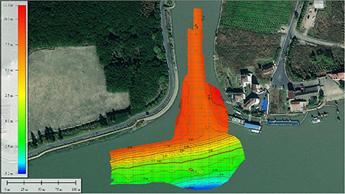
Traditional single beam echo sounders provide limited point-based depth measurements along survey lines. In contrast, the CHCNAV HQ-400 multibeam system delivers dense, full-coverage bathymetric data across a wide swath. This allows surveyors, engineers, and decision-makers to analyze underwater terrain with significantly higher confidence, especially in complex environments such as reservoirs, bridge structures, and dredging zones.

A single beam workflow typically provides isolated depth profiles along survey lines. A multibeam workflow captures dense bottom coverage across a wide swath, producing a much clearer representation of terrain, scour, objects, and underwater shape changes.
For reservoirs, bridge inspections, tailings ponds, and emergency response, that difference directly affects confidence in the result. The HQ-400 is built for teams that need more than sparse lines of depth data.
The value is not only the sensor. It is the combination of the integrated HQ-400, the Apache 4 USV platform, remote operation, dense multibeam data, and mission-ready workflows for challenging inland and near-shore environments.
Reduce the need to place crew on manned boats in shallow, obstructed, corrosive, or high-risk environments.
Dense bathymetric coverage helps reveal scour, terrain change, underwater features, and edge conditions that are difficult to understand with sparse depth lines.
Lightweight, compact, and integrated hardware helps teams mobilize faster for routine surveys, remote sites, or urgent response work.
4G + RC transmission, Android control, and integrated workflows support efficient field operation without bulky traditional setups.
Integrated IMU, PPK support, SVP integration, bottom tracking, and noise suppression help produce cleaner multibeam deliverables.
The Apache 4 platform supports multiple sensor workflows, allowing organizations to scale beyond one single survey use case.
These are the kinds of projects that help buyers immediately understand where the HQ-400 and Apache 4 platform fit into actual procurement, engineering, and regulatory workflows.

Challenge: limited access to manned boats, difficult logistics, and the need for credible volume data.
Solution: portable unmanned survey workflow with dense multibeam data and easier field deployment.
Why it matters: strong fit for water authorities, utilities, reservoir owners, and engineering consultants.

Challenge: diver inspection carries higher risk and sparse single-beam points may miss the real trend.
Solution: USV can scan close to piers while multibeam data reveals scour and bottom geometry in much greater detail.
Why it matters: very strong for bridge authorities, municipalities, and transport infrastructure owners.

Challenge: high pH, corrosive water, and industrial risk environments.
Solution: HQ-400 and Apache 4 platform positioned for safer measurement operations in demanding industrial sites.
Why it matters: ideal for mining operators, industrial consultants, and environmental compliance work.

Challenge: remote sites, high altitude, and no NTRIP login coverage.
Solution: lightweight system with radio communication support and PPK workflow for remote operations.
Why it matters: useful for environmental agencies, parks, consultants, and remote field crews.

Challenge: decision-makers need fast understanding of erosion, washout, or underwater changes during urgent events.
Solution: quickly produce 3D underwater topography to support response and rebuilding decisions.
Why it matters: powerful for emergency management, public works, and dam-related response planning.

Challenge: shallow edges, obstacles, moving water, and inefficient access with manned boats.
Solution: obstacle-aware USV platform with dense multibeam data and close-edge survey capability.
Why it matters: useful for inland waterways, terminal operations, dredging planning, and shoreline engineering.
HQ-400 is compact enough for small USV platforms, yet powerful enough for high-resolution multibeam work. The integrated design helps reduce installation complexity, cable clutter, and time spent configuring multiple independent survey components.
This makes the system attractive for teams that want high-end bathymetric capability without the overhead of a large conventional multibeam setup.

Lightweight Integrated Multi-Beam Echosounder
Compact and powerful system designed for high-resolution bathymetric and hydrographic surveys.

