CHCNAV P2 GNSS Positioning Sensor
CHCNAV P2 – High-Precision GNSS Positioning Sensor
Accurate, Reliable, and Versatile GNSS Solution for Your Fieldwork
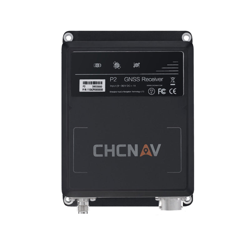
The CHCNAV P2 is a compact and robust GNSS positioning sensor designed for high-precision applications in surveying, mapping, and construction. Equipped with advanced GNSS technology and offering multi-constellation support, the P2 ensures reliable, real-time centimeter-level accuracy in a variety of challenging environments. Whether you're conducting land surveys, building infrastructure, or mapping large areas, the P2 provides the precision and efficiency required for demanding projects.
Key Features:
-
Multi-Constellation GNSS Support: The P2 supports GPS, GLONASS, Galileo, and BeiDou constellations, offering superior satellite coverage for enhanced accuracy and reliability in the field, even in areas with limited visibility.
-
Centimeter-Level RTK Accuracy: With real-time kinematic (RTK) technology, the P2 delivers centimeter-level positioning accuracy, ensuring high-precision results for survey-grade applications.
-
High-Performance GNSS Engine: The P2 is equipped with an advanced GNSS receiver and a powerful processor, delivering stable, reliable performance under a wide range of environmental conditions, from open fields to urban canyons.
-
Rugged and Durable Design: The P2 is built to endure tough conditions with an IP67 rating for water and dust resistance, ensuring reliable operation in harsh environments, whether exposed to rain, dust, or extreme temperatures.
- Easy Integration and Flexibility: The P2 is compatible with a wide range of surveying software and can be easily integrated into existing workflows, making it a versatile solution for a variety of professional applications.
Applications:
-
Surveying: Ideal for land surveys, boundary surveys, and construction layout, the P2 provides reliable GNSS data to ensure precision and accuracy in your field measurements.
-
Mapping and GIS: With its high-accuracy capabilities, the P2 is perfect for mapping large areas, GIS data collection, and land use planning.
Infrastructure and Construction: The P2 is an excellent choice for infrastructure projects, construction site layout, and staking out building foundations.
- Geospatial Data Collection: Use the P2 for gathering accurate geospatial data for various industries, from environmental monitoring to urban planning.
Why Choose the CHCNAV P2?
The CHCNAV P2 is the ideal solution for professionals requiring accurate and reliable GNSS RTK positioning in demanding environments. With multi-constellation support, centimeter-level accuracy, and a rugged design, the P2 ensures you can collect high-precision data even in challenging field conditions.
Maximize your fieldwork accuracy and efficiency with the CHCNAV P2 – the trusted GNSS RTK receiver for precision applications.
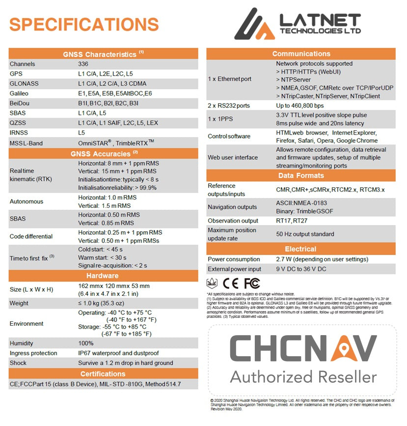
Technical Specifications
P2 High-Precision GNSS Positioning Sensor
P2 features
High-Precision GNSS Positioning Sensor