CHCNAV P5 GNSS Geodetic Reference Station
CHCNAV P5 – High-Precision GNSS Geodetic Reference Station
Reliable, Secure, and Continuous GNSS Data Collection for Demanding Applications
The CHCNAV P5 is a high-end GNSS geodetic reference station designed for continuous, precise GNSS data collection in various applications, including geodetic surveying, network RTK services, and scientific research. Its robust design, versatile connectivity options, and advanced data management capabilities make it a reliable choice for demanding environments.
Key Features:
-
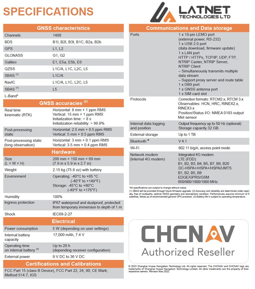
Advanced GNSS Tracking: The P5 features a GNSS receiver that simultaneously tracks GPS, GLONASS, Galileo, BeiDou, and SBAS signals, ensuring superior GNSS raw data quality
-
Continuous Operation: Designed for uninterrupted operation, the P5 supports both DC and AC external power inputs. Its high-capacity 17,000 mAh battery provides up to 20 hours of backup operation during external power outages, ensuring continuous data collection.
-
Versatile Connectivity: The P5 offers multiple network connection modes, including Intranet, Ethernet, 4G LTE, and Wi-Fi, facilitating easy access, configuration, and data transfer. Its redundant network connectivity feature allows automatic switching between Ethernet and 4G wireless networks, ensuring stable and reliable GNSS data streaming.
-
Robust Data Management: Equipped with 32 GB of internal storage and support for up to 1 TB of external storage, the P5 can simultaneously record up to eight separate data sessions in standard RINEX 3.02 format for up to seven years. Its embedded FTP server or FTP push to remote sites ensures data integrity and ease of use.
-
Enhanced Data Security: The P5 incorporates multiple security layers, including user permissions, web interface restrictions, HTTPS encryption, and built-in firewall, port, and MAC filtering to prevent unauthorized access.
- Durable Design: With an IP67 rating for water and dust resistance, the P5 is built to withstand challenging environmental conditions, reducing potential downtime due to moisture or dust ingress.
Applications:
-
Geodetic Surveying: Provides a stable and reliable reference for high-precision geodetic measurements and network RTK services.
-
Scientific Research: Ideal for continuous GNSS data collection in atmospheric, geophysical, and tectonic studies.
-
Infrastructure Monitoring: Supports deformation monitoring and stability assessments of critical infrastructure.
- Agriculture and Construction: Enhances precision in agricultural applications and construction site management through accurate GNSS data.
Why Choose the CHCNAV P5?
The CHCNAV P5 GNSS geodetic reference station combines advanced GNSS tracking, versatile connectivity, robust data management, and enhanced security features, making it a reliable solution for continuous, high-precision GNSS data collection in demanding environments.
Ensure uninterrupted and accurate GNSS data collection with the CHCNAV P5 – your trusted partner for geodetic reference applications.
Technical Specifications
P5 High-Precision GNSS Geodetic Reference Station
P5 Features
P5 High-Precision GNSS Geodetic Reference Station