


GeoCue TrueView 540 Lidar
GeoCue TrueView 540 Lidar is backordered and will ship as soon as it is back in stock.
GeoCue TrueView 540 – New Standard for Accuracy and Quality
Product Overview
The GeoCue TrueView 540 is a next-generation airborne LiDAR solution that combines high-density LiDAR and RGB imagery, designed for demanding UAV mapping and photogrammetry applications. This system leverages cutting-edge LiDAR technology from CHC Navigation (CHCNAV) with precision GNSS positioning and an advanced IMU for unparalleled accuracy and quality. Powered by the LP360 software suite, the TrueView 540 provides a streamlined workflow for efficient data processing and 3D visualization, setting a new standard in accessible, high-end LiDAR for professionals.
Why Choose GeoCue TrueView 540?
The TrueView 540 is engineered for professionals who demand high-quality, reliable, and accurate LiDAR solutions. Its unique combination of precision, versatility, and efficiency makes it suitable for a wide range of UAV-based LiDAR and photogrammetry applications. From topographic mapping to vegetation analysis and 3D model reconstruction, the TrueView 540 is an ideal solution for those seeking high-end results with accessible, user-friendly tools.
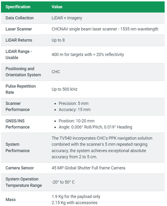
Technical Specification
TrueView 540
Sample Data – GeoCue TrueView 540 / CHCNAV AA10
This aerial dataset was captured using the TrueView 540, also known as the CHCNAV AlphaAir 10 (AA10) — a high-performance LiDAR scanner capable of recording up to
8 returns per pulse. Designed for forestry, terrain, and vegetation mapping, the AA10 sets a new standard in its weight class for
penetration through dense canopy and fine feature detection.
In this sample, you can clearly distinguish individual tree stumps and trunks, making it ideal for biomass analysis, tree segmentation, and forestry inventory applications.
The unmatched return density ensures nothing is missed — even in the most cluttered or occluded environments.
Note. To explore the dataset in detail: Double-click to zoom in; Use the scroll wheel to zoom in/out; Right-click and drag to pan across the scene;