


CHCNAV AlphaAir 9 Lightweight UAV LiDAR system for high-density aerial topographic surveys
AlphaAir9 LiDAR + RGB System
A Compact Professional UAV Mapping Solution
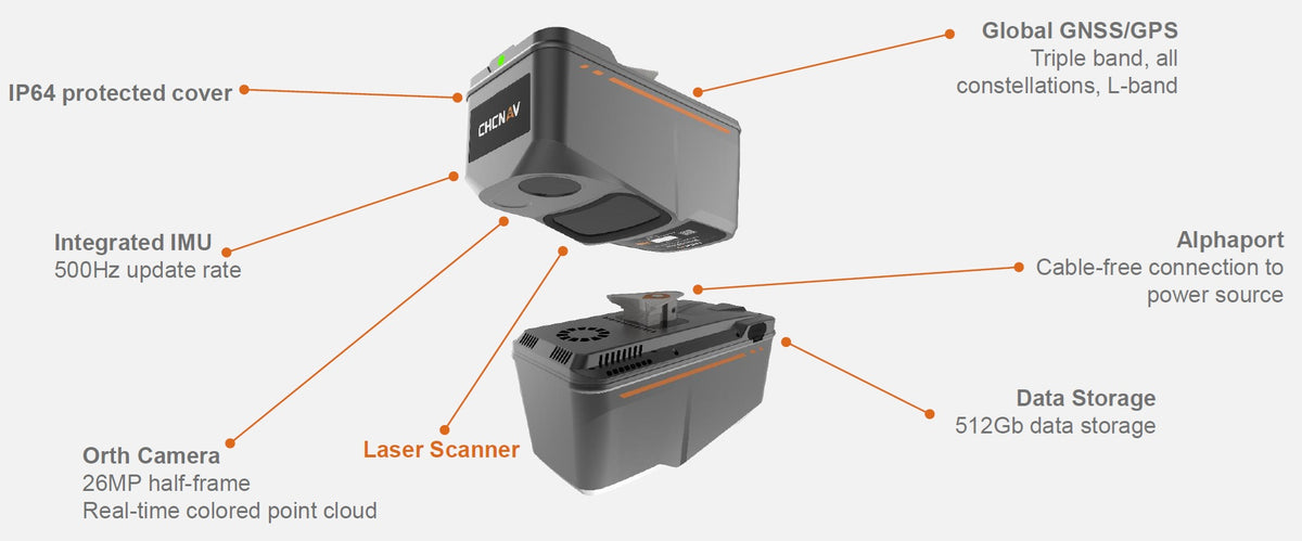
The CHCNAV AlphaAir 9 (AA9) is a powerful and lightweight aerial LiDAR + RGB system specifically designed for professional UAV mapping and photogrammetry. With a compact design weighing only 1.45 kg and fully integrating CHCNAV’s accurate LiDAR sensor, GNSS/IMU positioning, and 26 MP RGB orthographic camera, the AA9 delivers exceptional 3D data collection in a single flight.
Designed to seamlessly integrate with leading UAV platforms including the CHCNAV X500, DJI M350, and other third-party drones, the AA9 offers quick installation via CHCNAV’s innovative AlphaPort interface, supporting both power and telemetry with a single click.
Key Features:
-
Survey-Grade Accuracy:
Achieve absolute accuracy of 2-5 cm and 5 mm precision with advanced CHCNAV navigation algorithms, even in challenging conditions.
-
High-Density Point Cloud Capture:
With up to 500,000 points per second, 250 scan lines per second and a maximum range of 600 m, the AA9 provides detailed and reliable coverage for corridor, terrain and vegetation surveys.
-
Dense Vegetation Penetration:
With the ability to capture up to 6 return echoes, the AA9 is ideal for creating accurate terrain models in forested or cluttered areas.s. -
Integrated 26 MP RGB Camera:
Capture high-resolution imagery for orthophoto generation and true-color point cloud colorization. The built-in camera enables realistic 3D mesh reconstruction in combination with CHCNAV processing package. -
Streamlined Workflow with CoPre + CoProcess:
Post-processing is fast and intuitive with CHCNAV’s CoPre and CoProcess software, offering everything from trajectory correction and strip adjustment to automatic DEM/DSM creation and feature extraction. -
Real-time data preview & efficient operation:
Real-time point cloud and image preview via the UAV controller improve data confidence and mission decision-making. Runs for up to 30 minutes per flight when used with the DJI M350 and up to 45 minutes per flight when used with the CHCNAV X500
-
All-Weather Performance:
The IP64-rated housing ensures reliable operation in a variety of field conditions, from -20°C to +50°C.
Why Choose the CHCNAV AA9?
-
Lightweight & Versatile:
At just 1.45 kg, the AA9 is ideal for long-duration flights and easy transport. It mounts easy on popular UAVs like CHCNAV X500 and DJI M3300/M350. -
Accuracy You Can Trust:
Backed by CHCNAV’s robust GNSS/IMU platform and laser scanning engine, the AA9 delivers reliable and repeatable results in real-world conditions. -
Built for Productivity:
With a robust GNSS/IMU platform and laser scanning engine, the CHCNAV AA9 delivers reliable, repeatable results in real-world conditions.
-
Future-Ready Technology:
With real-time visualization, multi-return capability, and advanced camera integration, the AA9 offers features often found only in larger, more expensive systems. -
Seamless Support & Service:
As an authorized CHCNAV dealer in Canada, Latnet Technologies Ltd. provides full support, training, and integration guidance, ensuring you get the most out of your investment.
Technical Specification and Features
Alpha Air 9
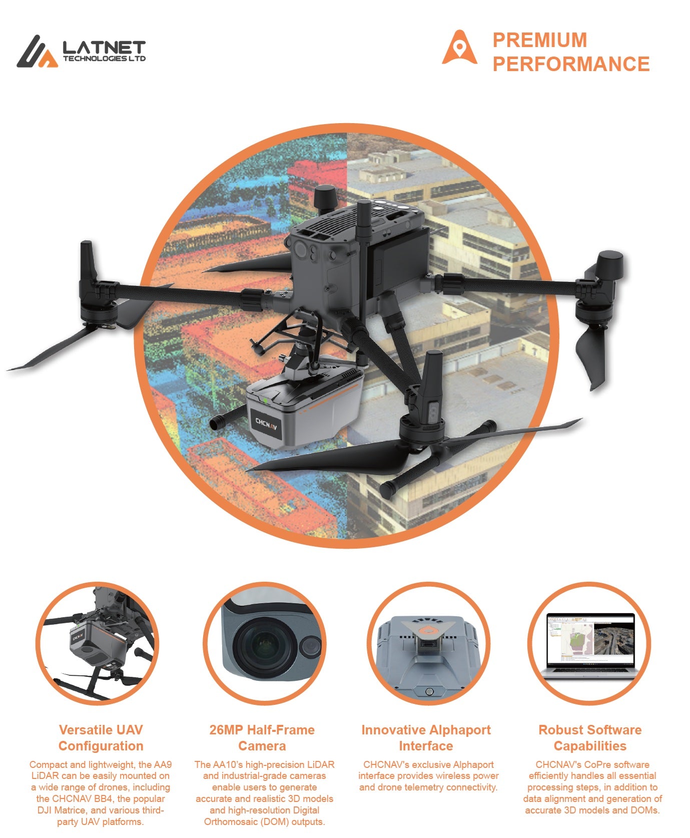
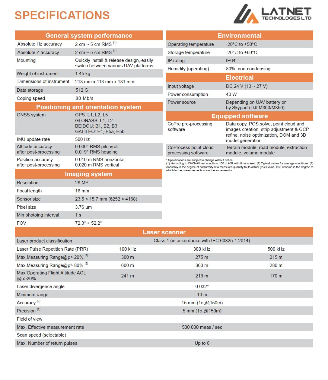
AlphaAir 9 features
Professional Airborne Lidar+RGB System
Engineered for Every Mission
Whether you’re mapping infrastructure, forests, construction sites, or supporting disaster recovery, the AA9 adapts to a wide range of applications. Its unmatched flexibility makes it the perfect fit for UAVs and fixed-wing platforms across industries.

Compact, Precise, Powerful
The CHCNAV AlphaAir 9 (AA9) is a lightweight, survey-grade airborne LiDAR system designed for demanding mapping jobs. Weighing only 1.45 kg and delivering absolute accuracy up to 5 cm, the AA9 is the go-to solution for projects where efficiency, precision, and versatility matter most.

See What Others Can’t
With up to 6 return echoes, the AA9 excels in penetrating dense vegetation to deliver accurate ground models. Outperforming standard systems, it captures more usable ground points, making it ideal for forestry, environmental, and corridor mapping applications.

Streamlined LiDAR Workflow from Mission to Model
From mission planning with SmartGo to processing in CoPre and final modeling in third-party software, the AA9 is fully integrated into a simplified, efficient LiDAR workflow. Reduce complexity and ensure data quality with seamless post-processing and information extraction.

Sample Data – CHCNAV AlphaAir 9 (AA9)
Explore a live point cloud captured with the AA9 LiDAR system. High-resolution Powerline detail. AA9 is optimized for forestry, infrastructure, corridor, and terrain mapping.
Note. To explore the dataset in detail: Double-click to zoom in; Use the scroll wheel to zoom in/out; Right-click and drag to pan across the scene;