


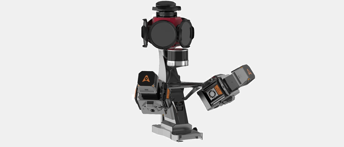
CHCNAV AU20 + AP7 Mobile Mapping LiDAR System with Ladybug Camera
CHCNAV AU20 + AP7 Mobile Mapping System with Ladybug Camera
High-Definition, AI-Enhanced Mobile LiDAR Mapping — Powered by Dual-Laser AU20
The CHCNAV AU20, mounted on the AP7 vehicle platform and integrated with a high-resolution Ladybug5+ or Ladybug6 panoramic camera, is a cutting-edge mobile mapping system designed for professionals who demand both precision and efficiency. It delivers survey-grade LiDAR point clouds fused with full-color imagery — all in a single drive.
Built for demanding applications like city modeling, highway and rail corridor mapping, utility inspection, and asset management, this system is engineered for high productivity in urban and complex environments.
Key Benefits & Capabilities
✅ Dual-Laser Powerhouse
Capture up to 2 million points per second with the AU20’s dual-head, full-waveform LiDAR sensors — ensuring maximum coverage and accuracy, even at higher speeds and longer ranges.
✅ 360° Spherical Imaging
The Ladybug5+ / Ladybug6 camera captures ultra-high-resolution (30–72 MP) panoramic images at up to 15 FPS. These visuals are precisely synchronized with the LiDAR stream for seamless point cloud colorization and visual documentation.
✅ AI-Driven Accuracy
Advanced trajectory correction and onboard filtering remove noise from moving objects like pedestrians and vehicles. The result: cleaner datasets and fewer hours spent in post-processing.
✅ Efficient One-Pass Surveys
Dual laser heads scan from multiple angles, minimizing blind spots and ensuring excellent coverage of road signs, lane markings, sidewalks, and building facades.
Why Choose the AU20 + AP7 System?
-
Smart Software Integration – CHCNAV’s SmartGo, CoPre, and CoProcess software suite streamlines mission planning, QA/QC, and deliverable generation.
-
Sensor-Ready Platform – The AP7 supports up to 8 auxiliary sensors (e.g., pavement cameras, GPR) for expanded capabilities.
-
Rugged and Reliable – Built to perform under harsh conditions with an IP64 rating, shock isolation, and real-time preview functionality.
-
Flexible Deployment – Easily mounted on pickups, SUVs, or survey vans — no need for custom vehicles or major retrofitting.
-
Backed by Local Support – Delivered and supported by LATNET Technologies, CHCNAV’s official Canadian dealer.
Whether you're mapping cities, inspecting highways, or documenting infrastructure, the AU20 + AP7 system is the go-to mobile LiDAR solution for fast, repeatable, and visually rich 3D data collection.
Technical Specification
CHCNAV AP7 + AU20 Mobile Mapping System
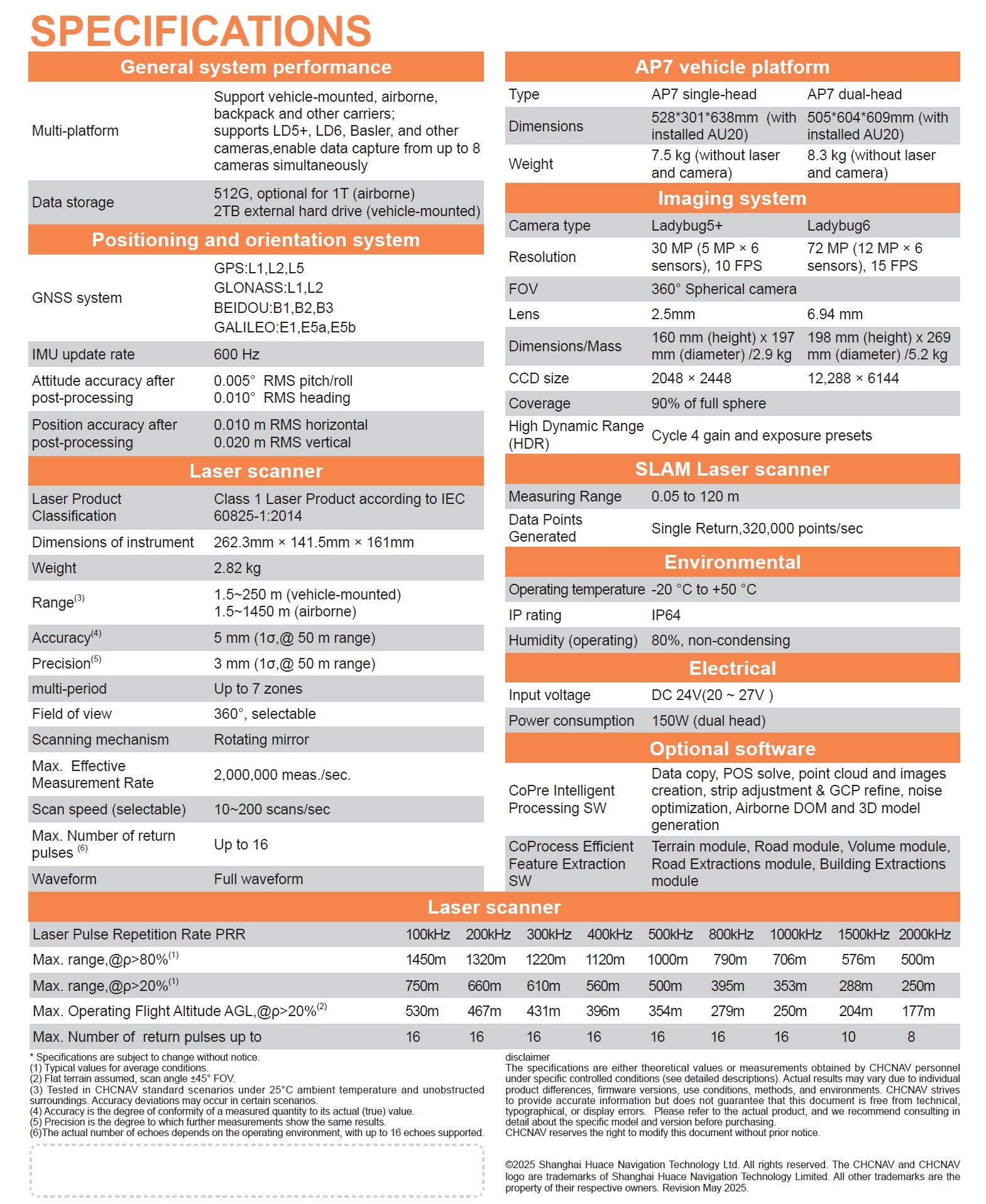
AP7 + AU20 features
High-precision vehicle-mounted mobile mapping system
Engineered for Precision and Power
The AP7 is CHCNAV’s next-generation vehicle platform built to support the AU20 Mobile Mapping System. Designed for heavy-duty fieldwork, its dual-laser capability and advanced sensor integration ensure precise point cloud coverage with no blind spots — even in complex urban or highway environments.

Panoramic Imaging
Choose between Ladybug5+ (30 MP) or Ladybug6 (72 MP) calibrated panoramic cameras to capture immersive, high-resolution 360° imagery. Perfectly synchronized with LiDAR data, these cameras offer reliable documentation and vivid colorization for mobile mapping missions.

Millimeter-Level Accuracy
The AU20 + AP7 delivers unprecedented precision, capturing even the subtle elevation differences between road markings and the surrounding pavement. With 5 mm accuracy and 3 mm precision, this system is engineered for high-definition applications where every millimeter counts.


Smart AI Colorization
Thanks to AI-driven point cloud processing, the system intelligently detects obstructions, surface variations, and shadowed regions to improve color mapping. The result is cleaner, more consistent colorization that enhances both visualization and downstream analysis.

Reliable Scanning in GNSS-Denied Environments
The AP7 + AU20 system demonstrated exceptional performance during a 4.8 km tunnel scan with no GNSS signal. By utilizing SLAM-assisted data refinement and high-stability mounting, it achieved precise trajectory correction with only 15 mm deviation. This ensures clean, consistent point clouds even under full satellite denial.

All-In-One Workflow from Hardware to Deliverables
The AU20 + AP7 platform integrates everything you need for mobile LiDAR mapping: from hardware configuration to SmartGo mission planning, and CoPre / CoProcess software for data correction and feature extraction. This unified system minimizes setup time, streamlines operations, and delivers high-quality results efficiently.

CHCNAV AP7 + AU20 Mobile Mapping System
Premium Mobile Mapping Solution


Urban Mapping in Motion: AU20 Vehicle-Mounted LiDAR
Captured using the CHCNAV AlphaUni 20 (AU20) mounted on a vehicle, this dataset highlights the system’s ability to scan dense city environments with exceptional detail and speed. From road surfaces and curbs to facades, signage, and vegetation, the AU20 delivers survey-grade accuracy across every frame — ideal for urban planning, infrastructure maintenance, and 3D city modeling.
Note. To explore the dataset in detail: Double-click to zoom in; Use the scroll wheel to zoom in/out; Right-click and drag to pan across the scene;