SLAM LiDAR Explained: How Handheld 3D Scanning Has Changed the Way We Map
A practical guide to SLAM technology, how it differs from traditional LiDAR workflows, and where the CHCNAV RS10 and RS7 fit for Canadian survey professionals.

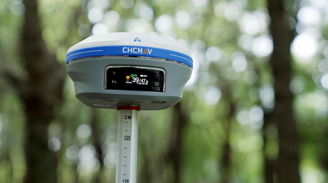
CHCNAV RS10 in use — the operator walks continuously while the scanner builds a georeferenced 3D point cloud in real time, indoors and outdoors in the same session.
What is SLAM LiDAR — and why does it matter?
Walk into a building with a total station and you'll spend the first 30 minutes setting up, backsighting, and levelling before a single point gets recorded. Fly a UAV over the same building and you capture the roof well — but the interior, stairwells, and underground parking stay dark. Neither approach covers the full picture on its own.
SLAM LiDAR was developed to address exactly that gap. It combines a laser scanner with real-time positioning algorithms to create a system that knows where it is as it moves, building a georeferenced 3D model on the fly — no setup station, no fixed reference, and no return loop required in most cases.
The abbreviation breaks down cleanly: LiDAR (Light Detection and Ranging) measures distances to surrounding objects using pulsed laser beams. SLAM (Simultaneous Localization and Mapping) processes that data to do two things at once — build a map of the environment and track the sensor's position within it. Put them together and you get a system that produces survey-grade point clouds while an operator simply walks through the space.
Scans that previously required multiple tripod setups and half a day of fieldwork can now be completed in a single continuous walkthrough of under an hour. For mixed indoor–outdoor projects, the difference in productivity is substantial.
How traditional scanning compares
To understand what SLAM LiDAR actually changes, it helps to see what came before it.
Static terrestrial laser scanning (TLS)
A tripod-mounted scanner placed at multiple stations throughout a site. Each setup captures a full 360° scan. To stitch those scans together, the crew places targets or uses cloud-to-cloud registration software. The results are excellent — sub-centimetre accuracy is routine — but the workflow is slow, setup-intensive, and poorly suited to environments where planting a tripod every five metres is impractical.
UAV LiDAR
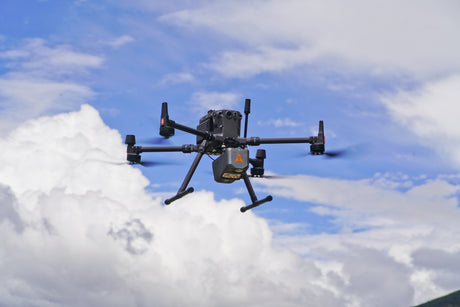
Systems like the CHCNAV AlphaAir 6 can collect millions of points per second from the air, covering large corridors or terrain areas far faster than ground-based scanning allows. But UAVs are constrained to what they can see from above. Interiors, tunnels, dense forest canopy, and anything requiring ground-level perspective still require a different tool.
SLAM LiDAR fills the space between those two methods. It is fast enough for a continuous walkthrough workflow, accurate enough for engineering applications, and flexible enough to work indoors, outdoors, underground, and anywhere in between.
RS7 vs RS10: which SLAM scanner is right for your project?
CHCNAV produces two handheld SLAM LiDAR platforms available through Latnet Technologies in Canada. Both support RTK, PPK, and GCP georeferencing and both work indoors and outdoors — the differences are in hardware capability and what each is optimised for.
CHCNAV RS7
The RS7 is built around Deep INS + SLAM fusion with a 500 Hz tactical-grade IMU (0.5°/h bias instability). Like the RS10, it supports RTK, PPK, and GCP georeferencing — when GNSS is available outdoors, it can anchor the trajectory the same way. Where the RS7 genuinely stands apart is indoors, where GNSS isn't available and the scanner has to rely entirely on inertial and geometric data. The tactical-grade IMU and 64-channel LiDAR give it more to work with than a standard IMU and fewer scan lines would: drift accumulates more slowly, loops can be shorter, and the data quality in feature-poor environments — long corridors, stairwells, repetitive floor plans — stays tighter. Dual 12 MP cameras using high-sensitivity sensor technology deliver sharp colorized output even in low-light conditions. 3DGS and mesh outputs are optional. Battery life is 150 minutes from a single charge.
| Specification | RS7 |
|---|---|
| LiDAR channels | 64-line |
| Point rate | Up to 1,152,000 pts/sec (dual return) |
| Range | 40 m @10% reflectivity |
| Field of view | 360° × 189° |
| Absolute accuracy | H/V <3 cm RMS |
| Relative accuracy | <1 cm |
| Repeatability | <2 cm |
| IMU update rate | 500 Hz |
| IMU bias instability | 0.5°/hr (tactical-grade) |
| Cameras | 2 × 12 MP HD (high-sensitivity, low-light) |
| 3DGS / mesh output | Optional (device licence required) |
| Weight | 1,200 g (with battery handle) |
| Battery | 150 min per charge |
| IP rating | IP64 |
| GNSS | GPS / GLONASS / BeiDou / Galileo / QZSS |
CHCNAV RS10
The RS10 is the mixed-environment scanning platform — built for projects that cover ground outdoors and inside in a single continuous session. It integrates a 4th-generation GNSS Smart Antenna (1,408-channel iStar2.0), fused with INS and SLAM. It is particularly well suited to large-scale topographic surveys, stockpile and earthwork volumetrics, infrastructure inspection, and corridor mapping where georeferenced point clouds need to cover significant outdoor area as well as accessible interiors. The 32-line version extends effective range to 300 m, practical for open terrain and corridor work. Three 5 MP cameras provide colorized output. The RS10 also operates as a conventional RTK rover in LandStar survey mode — that workflow is covered in the software section below. 3DGS and mesh outputs are optional. 3DGS requires an Insta360 camera with a mounting bracket on the RS10. Available in 16-line (0.05–120 m, 1.9 kg) and 32-line (0.5–300 m, 1.7 kg) configurations.
| Specification | RS10 (16-line / 32-line) |
|---|---|
| LiDAR channels | 16 / 32 |
| Point rate (single/dual return) | 320k/640k pts/sec / 640k/1,280k pts/sec |
| Range | 0.05–120 m / 0.5–300 m |
| FOV (H × V) | 360° × 270° |
| Absolute accuracy (H/V) | <5 cm RMS / <2 cm RMS |
| Relative accuracy | <1 cm (both) |
| Max session area | ~13,000 m² |
| IMU update rate | 200 Hz |
| Cameras | 3 × 5 MP (15 MP total, colorization) |
| Mesh output | Optional CoPre add-on — licence required, no extra hardware |
| 3DGS output | Optional — requires Insta360 camera (bracket-mounted) + licence |
| Weight | 1.9 kg (16-line) / 1.7 kg (32-line) |
| Battery | ~60 min, hot-swappable |
| IP rating | IP64 |
| GNSS | 1,408-ch iStar2.0 RTK (GPS/GLONASS/Galileo/BeiDou/QZSS/NavIC) |

CHCNAV RS7 — 64-channel handheld scanner with tactical-grade INS, dual 12 MP cameras, and 150-minute battery, built for intensive indoor campaigns.
How to choose: Both scanners work indoors and outdoors, and both can produce georeferenced output via RTK, PPK, or GCPs. The RS7's strength is sustained interior work — its 64-channel LiDAR, tactical-grade IMU, and 150-minute battery make it the more capable tool for large buildings, multi-floor structures, heritage recording, and any project where you're spending most of the session inside without a clear outdoor GNSS anchor. The RS10 is the better fit when the project involves significant outdoor sections, needs the built-in RTK antenna anchoring the trajectory in real time, or requires long-range scanning beyond 40 m. Many firms run both.
How the RS10 works: RTK + SLAM + INS fusion
The RS10 fuses three positioning technologies in real time — RTK GNSS for absolute outdoor accuracy, SLAM for geometric consistency, and INS (inertial navigation) to bridge transitions and carry the trajectory when GNSS is unavailable.
RTK GNSS
Provides absolute position outdoors — the same centimetre-level accuracy used in conventional survey workflows, but integrated directly into the scanner. When connected to a CORS network (including Latnet's own RTK correction network covering Alberta), no separate base station is required in the field.
INS + SLAM — always running
SLAM and INS run continuously throughout every session — not just when GNSS is unavailable. Outdoors, GNSS, INS, and SLAM all contribute to the trajectory solution together; GNSS provides the absolute position anchor, and SLAM adds geometric consistency. Indoors, where GNSS drops out, INS and SLAM carry the full positioning load. The transition is automatic.
SFix and Vi-LiDAR — surveying mode features
When the RS10 is used as an RTK rover in LandStar survey mode (not during SLAM scanning), two additional capabilities become available. SFix calculates a precise range-pole tip coordinate for up to one minute after satellite signal loss — useful for surveyors working near building edges or under short obstructions. Vi-LiDAR allows contactless coordinate capture from the live LiDAR feed to 5 cm accuracy at 15 m, without placing a physical target.
Outdoors, GNSS anchors the trajectory to absolute coordinates while INS and SLAM run alongside it. When the scanner moves inside, GNSS drops out and INS + SLAM carry the full load. Because GNSS fixes the position continuously whenever signal is available, accumulated drift stays bounded — which is what makes open-ended scanning routes practical.
Loop closure — when it's needed and when it isn't
Loop closure is one of the more counterintuitive constraints in SLAM scanning. The issue is positional drift — even with a good IMU and dense LiDAR data, the estimated position accumulates small errors over time. Walk a long corridor and end up far from where you started, and those errors compound until the end of the point cloud no longer aligns cleanly with the beginning.
The traditional fix is to return to the starting point, let the software detect the geometric match between start and end, and redistribute the accumulated error across the trajectory. It works — but it constrains how you plan your route.
Whether loop closure is needed depends on how the scanner is being used, not which scanner you're using. Both the RS7 and RS10 follow the same logic:
With RTK, PPK, or GCPs — loop closure not required
When GNSS is available and providing a fix, or when the trajectory is constrained by PPK post-processing or surveyed ground control points, the trajectory is anchored to independent absolute positions. Accumulated drift has nowhere to build up — each fix is a hard constraint on the solution. You can walk any route you like, enter a building through one door and exit through another, and the trajectory will be consistent. Both the RS7 and RS10 support RTK, PPK, and GCP workflows through the same CoPre processing pipeline.
SLAM-only (no GNSS, no GCPs) — loop closure improves accuracy
When scanning in a purely GNSS-denied environment with no control points — deep inside a building, underground, in a tunnel — the system has no external position reference. In this mode, loop closure remains an important tool for keeping the trajectory consistent over long traverses. This is where the RS7's hardware advantages matter most: the 500 Hz tactical-grade IMU (0.5°/h bias instability) and 64-channel scanner generate higher-quality inertial and geometric data, so drift accumulates more slowly, loops can be shorter and less frequent, and the error corrections applied are smaller. The RS10 can work in the same SLAM-only mode, but its 200 Hz IMU and 16 or 32 scan lines give it less to work with in demanding feature-poor environments.
In practice: use RTK, PPK, or GCPs wherever possible — that's the cleanest workflow on either scanner. When you're working somewhere GNSS can't reach and GCPs aren't practical, the RS7's stronger IMU and denser scan data give it a meaningful edge in keeping drift under control.

RS10 in a tunnel — GNSS anchors the trajectory outdoors, INS and SLAM carry it through the GNSS-denied section. With RTK or GCPs, no loop closure required.
Seamless indoor–outdoor transition
Many survey projects span both environments. A building condition assessment might require scanning the facade, loading dock, lobby, mechanical room, and roof within a single project deliverable. An infrastructure inspection might cover the outside of a tunnel portal, the interior, and the surrounding embankments. Heritage documentation regularly requires both architectural exterior recording and interior spatial capture.
Before integrated SLAM scanners, these projects meant two separate tools and two separate coordinate systems merged in the office. With the RS10, a single session covers both environments in one georeferenced point cloud. GNSS handles the exterior; SLAM handles the interior; the transition is automatic.
The operator walks from outside to inside, keeps scanning, and the system handles positioning continuity in the background. No recalibration, no target placement at the threshold, no second coordinate system to merge later.
Adding control points for higher accuracy
For projects that require improved absolute accuracy beyond what integrated RTK alone provides — tight-tolerance as-built surveys, legal boundary documentation, or work delivered against a specific client accuracy standard — both the RS10 and RS7 support the addition of surveyed control points during processing.
Ground control points are collected during the scan session by touching the tip of the scanner handle to a known point — a nail, a marked cross, or any identifiable feature — and logging it in SmartGo. These trajectory control points are then imported into CoPre during processing, where they constrain and refine the trajectory, improving absolute accuracy across the entire scan.
This makes both scanners appropriate across a wide accuracy spectrum — from rapid reconnaissance and asset inventory through to engineering-grade as-built documentation, with GCPs pushing accuracy as far as the project requires.
Processing software: from raw scan to final deliverable
A SLAM scanner is only as useful as the software that turns raw field data into a deliverable. The CHCNAV ecosystem covers the full chain: field capture in SmartGo, cloud processing via CoCloud, desktop post-processing in CoPre, and CAD drafting in CoProcess. For corridor, infrastructure, and any project needing surgical control over the point cloud, TerraSolid is covered at the end of this section.
SmartGo — field acquisition (both scanners)
Both the RS7 and RS10 use SmartGo for field data acquisition. The live point cloud display lets the operator see in real time where the scanner has and hasn't covered — useful for confirming complete coverage and catching missed areas before leaving the site. SmartGo also shows scanner status, satellite count, GNSS fix quality, and storage remaining. Data is stored onboard the scanner and copied to a computer after the session for processing in CoPre.
LandStar — field survey app (RS10)
The RS10 operates in rover mode with CHCNAV's LandStar field survey software, enabling topographic survey, point and line stakeout, elevation checks, and facade survey directly from the scanner. Vi-LiDAR allows contactless coordinate capture to 5 cm at 15 m without placing a physical target. In surveying mode, SFix comes into play when GNSS signal is briefly lost — under a bridge or short overhang, for example — the SLAM algorithm takes over to calculate the range-pole tip position, allowing the surveyor to keep collecting points for up to a minute without stopping.
CoPre — intelligent post-processing (both scanners)
CoPre handles the core processing pipeline for both scanners: trajectory optimisation (POS processing with RTK, PPK, or GCP), point cloud generation, adjustment and refinement, 3D modelling, colorization, and delivery export. Both the RS7 and RS10 can produce the same output types: colorized point clouds, mesh models (OSGB/OBJ), and 3D Gaussian Splatting (3DGS). Export formats include LAS, LAZ, E57, RCS, and other standard formats compatible with CloudCompare, Autodesk ReCap, Trimble RealWorks, Leica Cyclone, Revit, and TerraSolid (TerraScan / TerraModeler). Processing time depends on workstation spec — an NVIDIA GPU is required for high-precision colorization, mesh, and 3DGS workflows. Smaller projects process quickly; large multi-floor or multi-session datasets take longer and benefit from a 64 GB RAM machine with a mid-range or better NVIDIA card.
CoProcess — from floor plans to stockpile volumes, all in one place
CoProcess takes raw RS7 and RS10 point clouds and turns them into finished deliverables — classified data, floor plans, elevation drawings, terrain models, road extractions, volume reports, and DWG files — all inside one application. It works with data from any LiDAR system, not just CHCNAV hardware. The software is organized into four modules: Foundation (project setup, visualization, point cloud management), Terrain (DTM/DEM/DSM generation, contours, slope analysis), Road (road feature extraction, cross-sections, road design), and Volume (stockpile measurement, earthwork calculation, multi-temporal change tracking).
Large datasets, no compromise: CoProcess handles single-session datasets up to 300 GB at full resolution — no thinning, no tile splitting. A 100 GB dataset runs terrain classification in roughly two hours on a standard workstation. That means a multi-floor RS7 building scan or a long RS10 corridor survey stays in one project file from start to finish.
Classification — automatic, semi-automatic, and manual: Ground, vegetation, buildings, roads, power lines — AI algorithms sort the cloud automatically. On high-density RS7 or RS10 scans, automated classification achieves 95%+ accuracy, shifting the work from categorizing to reviewing. For anything the automation misses or misclassifies, half-automatic and manual tools give full control over every point. The classification output feeds directly into extraction, drafting, and terrain workflows without leaving the application.
Terrain modeling: The Terrain module generates DEMs, DSMs, and contour lines from classified ground points. Survey-grade terrain models, slope maps, and elevation difference comparisons between scan sessions all come out of this module. For RS10 topographic surveys, stockpile monitoring, and construction earthwork tracking, this is where the data becomes an engineering deliverable without any export step in between.
Road extraction and cross-sections: The Road module extracts road features automatically and manually — lane markings, kerbs, road edges, breaklines — and exports them in SHP or DXF for direct use in AutoCAD and ArcGIS. Road cross-sections and longitudinal profiles can be generated and exported at any interval. For RS10 corridor surveys, this cuts the manual extraction work that would otherwise be done point-by-point in CAD.
Volume calculations and change detection: Stockpile and earthwork volumes are calculated directly from classified point clouds using a grid method and exported in DXF. Multi-temporal analysis — loading two scan sessions from the same site and running a change comparison — produces a quantified report of what moved and by how much. Directly applicable to quarry stockpile monitoring, construction earthworks, and any project where repeat scans track progress over time.
Facade and floor plan documentation: Depth Rendering mode recovers surface detail on dark and shadowed facades independently of RGB or intensity data. On-the-fly horizontal and vertical slicing generates real-time cross-sections at any height for floor plan and elevation drafting. Plan-Elevation Sync generates elevation views automatically from floor plan geometry. Adjacent-surface consistency checking keeps walls, floors, and ceilings aligned during drafting. Building contour, door, and window extraction is automated, with results going straight into the DWG drafting environment.
Native DWG output: Draft directly on standard CAD layers, import your own templates, use automated dimensioning and annotation, and export finished drawings to AutoCAD, Revit, or Civil 3D. Final deliverables also export as DXF, DAT, SHP, TIF, and other formats for integration with ArcGIS and third-party CAD platforms.
| Module / Capability | What it does with RS7/RS10 data |
|---|---|
| Foundation — up to 300 GB, no thinning | Manage, visualize, and classify point clouds of any size in one session |
| AI + manual classification | Ground, veg, buildings, roads, power lines — auto with manual override |
| Terrain — DEM, DSM, contours, slope | Survey-grade terrain models direct from RS10 topo and stockpile scans |
| Road — feature extraction, cross-sections | Lane markings, kerbs, road edges to SHP/DXF; profiles at any interval |
| Volume — stockpile calc, change detection | Grid-based volumes and repeat-scan change reports, exported to DXF |
| Facade — Depth Rendering, occlusion fill | Complete elevation drawings regardless of lighting or shadows |
| Floor plans — on-the-fly slicing, Plan-Elevation Sync | Cross-sections and elevation views from point cloud without re-exporting |
| DWG-native drafting environment | Deliver to AutoCAD, Revit, Civil 3D, ArcGIS — no format conversion |
CoCloud — device-to-cloud workflow (RS7 and RS10)
Both the RS7 and RS10 integrate with CHCNAV CoCloud. Field data uploads with a single click and processing runs automatically in the cloud — point clouds, mesh models, and 3DGS results are ready for sharing and delivery without a local processing workstation. Useful for firms managing high scan volumes or remote project delivery where crews don't carry office-spec machines to the field.
TerraSolid — when you need the full toolkit
TerraSolid has been the industry standard for professional LiDAR data processing for over 25 years. It is the tool of choice for road, rail, utility corridor, power line, and urban mapping workflows worldwide — used by everyone from national mapping agencies to small survey shops. The modules run as plugins inside MicroStation (Bentley's CAD platform) or Spatix (a lightweight standalone CAD platform included with every TerraSolid licence at no extra cost — no MicroStation needed). RS7 and RS10 data loads into TerraSolid via LAS or LAZ point cloud and trajectory file together, which gives the software everything it needs for classification, extraction, and strip adjustment.
TerraScan is the core module and the reason TerraSolid has the reputation it does. It handles point clouds of any size from any sensor — mobile mapping, airborne, UAV, or handheld SLAM. Classification is the centrepiece: fully automatic routines for ground, vegetation, buildings, roads, power lines, and rail, refined with half-automatic and manual tools when the automatic pass needs correction. A macro and batch processing system lets production workflows run largely unattended. From classified data, TerraScan extracts 3D vector data automatically: building models to LOD2 specification over large areas, power line network vectorization, corridor analysis identifying clearance violations and danger objects, road surface condition assessment including paint line and curbstone detection, rail and overhead wire analysis, line-of-sight and clearance calculations, and change detection between datasets. Tunnel analysis tools handle underground scanning specifically. The results feed directly into TerraModeler, TerraPhoto, and TerraMatch without leaving the environment.
TerraModeler builds and manages surface models — TINs, DTMs, DEMs, DSMs, contours, cross-sections at any interval, volume calculations, and elevation difference maps between successive datasets. For RS10 topographic, stockpile, and corridor surveys where the deliverable is a terrain model and full control over every surface parameter is required, TerraModeler is the downstream tool. Mathematical and cartographic contour lines are both available; the latter produces the smooth, publication-quality output expected in mapping deliverables.
TerraPhoto handles image processing alongside the point cloud: camera calibration, rectification, colorization of the point cloud using images from the RS7's or RS10's onboard cameras, orthophoto production, and image mosaicking for corridor and urban documentation projects.
TerraMatch improves accuracy by working on the raw point cloud and trajectory simultaneously. It computes corrections for boresight angles (the physical misalignment between scanner and IMU), lever-arm offsets, and range scale factors. For RS10 multi-pass corridor surveys, TerraMatch compares overlapping strips, calculates the corrections needed to remove systematic misalignment errors that survive GNSS/PPK processing, and applies them across the entire dataset. It also handles fluctuating GNSS accuracy using tie lines and control measurements — essential for long corridors where satellite geometry changes along the route. Adjacent strips end up aligning to sub-centimetre tolerance rather than relying on the raw trajectory alone.
CoProcess vs TerraSolid: Both work with RS7 and RS10 data and both handle classification, terrain modeling, volumetrics, and feature extraction. CoProcess is built around scan-to-CAD-drawing delivery — floor plan slicing, facade depth rendering, road cross-sections, DWG-native drafting, and AI classification in one connected workflow. TerraSolid gives you a deeper and more configurable toolset: more classification options, broader extraction capabilities (buildings, power lines, rail, tunnels, road condition, change detection), batch processing macros for production workflows, and boresight calibration via TerraMatch. If you need to deliver a DWG drawing or a DXF volume report from a scan, CoProcess gets you there directly. If you're running a high-volume production operation, need to extract features across large datasets, or need the precision calibration tools for multi-pass corridor work, TerraSolid is built for it. Both are available through Latnet Technologies.

RS7 end-to-end workflow: SmartGo field capture → one-click CoCloud upload → CoProcess for point cloud, mesh, 3DGS, and CAD deliverables.
CHCNAV RS10 in action — integrated RTK GNSS, SLAM scanning, real-time point cloud preview, and field demonstration of the scanner's indoor and outdoor capabilities.
Applications for SLAM LiDAR in Canadian surveys
The RS7 and RS10 cover overlapping but distinct application territory. Where a project is primarily interior or involves dedicated building campaigns, the RS7's 150-minute battery, 64-channel scanner, and high-grade IMU make it the more capable tool. Where a project crosses into outdoor environments or requires absolute RTK georeferencing, the RS10 takes over.
BIM and as-built documentation (RS7 or RS10)
Interior scans for building information model updates, renovation planning, or facilities management. The RS7's 64-channel scanner and 150-minute battery are particularly suited to large multi-floor buildings where session length and point density matter. The RS10 handles buildings that also require exterior capture in a single continuous session.
Heritage documentation and cultural tourism (RS7 primary)
The RS7's dual 12 MP cameras with high-sensitivity sensor technology and optional 3D Gaussian Splatting output produce photorealistic interior models that go beyond standard colorized point clouds. For heritage structures, museums, cultural sites, and preservation projects where visual fidelity matters as much as geometry, the RS7 is specifically listed by CHCNAV for cultural tourism and heritage preservation applications.
Public safety and forensic investigation (RS7 primary)
Scene documentation for law enforcement, fire investigation, and forensic analysis. The RS7's rapid deployment, loop-free indoor capability, and high-resolution camera output support fast, complete scene capture without extensive setup. CHCNAV specifically lists public safety and forensic investigation as a primary RS7 application.

RS7 interior point cloud — 1.15 million points per second across a 360°×189° FOV preserves fine geometry, edges, and surface texture at walking speed.
Infrastructure inspection (RS10 primary)
Bridges, culverts, overpasses, utility corridors, and pipeline right-of-ways. The RS10 captures exterior geometry as well as accessible interiors in a continuous georeferenced session — the 300 m range on the 32-line version is practical for corridor work. Road surveying is listed as a primary RS10 application scenario on the datasheet.
Forestry and under-canopy surveys (RS10 primary)
Forestry asset management is listed as an RS10 application scenario. UAV-derived ground returns become sparse and unreliable under dense canopy; the RS10 works at ground level with full returns regardless of canopy density. For forest inventory, under-canopy terrain, and power-line corridor inspection where aerial access is blocked, SLAM scanning at ground level is typically the more reliable approach.
Mining and underground mapping (RS7 or RS10)
Drift surveys, stope mapping, shaft profiling, and tunnel as-builts. The RS7's INS-based positioning and loop-free indoor capability make it well suited to extended underground traverses where GNSS is never available. The RS10 handles mixed workflows — scanning the portal, adit, and surrounding surface area in a single georeferenced session.
Stockpile measurement and topographic surveying (RS10 primary)
Stockpile and topographic surveying are RS10 application scenarios particularly suited to outdoor sites — quarry, mining yard, and construction earthworks — where the integrated RTK anchors the point cloud to real-world coordinates for direct volume calculation. For indoor volumetric work — warehouse rack surveys, ore storage in underground facilities, indoor stockpiles — the RS7's 150-minute battery and strong INS performance make it the better-suited tool.
Construction monitoring and old community redevelopment (RS10 primary)
Progress documentation against design models, clash detection, and redevelopment surveys of existing built environments. Old community redevelopment is a specific RS10 application in CHCNAV's documentation — the combination of outdoor and indoor coverage in a single georeferenced session is directly applicable to block-scale surveys of existing urban fabric.
SLAM LiDAR vs. static scanning: choosing the right tool
| Factor | Static TLS | RS7 (indoor-focused) | RS10 (mixed environment) |
|---|---|---|---|
| Setup time | 5–20 min per station | None — continuous walkthrough | |
| LiDAR channels | Varies (typically 1 beam) | 64-line | 16-line or 32-line |
| Point rate | Up to ~2M pts/sec (high-end) | Up to 1,152,000 pts/sec | Up to 640,000 / 1,280,000 pts/sec |
| Range | Typically up to 300+ m | 40 m @10% reflectivity | 120 m (16-line) / 300 m (32-line) |
| Absolute accuracy | <5 mm | H/V <3 cm RMS | <5 cm (16-line) / <2 cm (32-line) RMS |
| Relative accuracy | <2 mm | <1 cm | <1 cm |
| Cameras | Usually integrated (varies by system) | 2 × 12 MP HD (colorization; 3DGS optional with licence) | 3 × 5 MP (colorization; 3DGS optional via Insta360 + licence) |
| Indoor–outdoor transition | Possible — register scans to common targets or surfaces in CoPre/TerraSolid | Works indoors and outdoors; RTK/PPK/GCPs for absolute georef | Continuous single session; built-in RTK anchors outdoors automatically |
| Georeferencing | Via targets or control points | RTK / PPK / GCPs | RTK / PPK / GCPs (integrated high-grade GNSS antenna) |
| Loop closure | No | Needed for SLAM-only mode; not needed when RTK/PPK/GCPs used | Needed for SLAM-only mode; not needed when RTK/PPK/GCPs used |
| Battery | AC / battery pack varies | 150 min per charge | 60 min, hot-swappable |
| System weight | 5–10+ kg with tripod | 1,200 g | 1.9 kg (16-line) / 1.7 kg (32-line) |
| Best environment | Millimetre tolerance, static scenes | Large interiors, heritage, forensics | Mixed projects, outdoor, infrastructure |
Static scanning remains the appropriate choice for millimetre-tolerance work — industrial metrology, deformation monitoring, and tight as-built documentation where every fraction of a centimetre counts. For projects where speed of coverage, mixed indoor/outdoor access, or rapid deployment matter more than sub-centimetre precision, the RS7 and RS10 cover different parts of that space. Neither replaces the other entirely; many firms run all three tool types depending on the project.
Frequently Asked Questions
What is the difference between the CHCNAV RS7 and RS10?
Both are handheld SLAM scanners, but with different positioning architectures. The RS10 integrates a 4th-generation RTK GNSS antenna (1,408-channel iStar2.0), making it a full RTK+SLAM fusion system that georeferences outdoor point clouds to absolute coordinates and genuinely eliminates loop closure dependence outdoors. The RS7 uses Deep INS + SLAM fusion with a 500 Hz tactical-grade IMU (0.5°/h gyro bias instability) — its high-grade inertial unit keeps drift tight enough in indoor environments that loop corrections are small and routes stay manageable, but the SLAM math still benefits from loop closure in long pure-indoor traverses. On hardware, the RS7 carries a 64-channel scanner versus 16 or 32 on the RS10, dual 12 MP HD cameras with built-in 3DGS output (HPGS 2.0), and runs 150 minutes per charge versus 60 minutes for the RS10. Both work indoors and outdoors. The RS7's strength is sustained interior scanning; the RS10's is mixed-environment projects requiring absolute georeferencing.
Do the RS7 and RS10 require a base station?
Not necessarily. When connected to a CORS-based correction network — such as Latnet's own RTK network in Alberta or other provincial correction services — both scanners receive RTK corrections over cellular with no base station required. For the highest absolute accuracy, particularly in remote areas beyond CORS coverage, placing a conventional GNSS base station on a known point to collect static RINEX data during the scan session enables a PPK workflow in CoPre — this post-processed approach typically delivers better trajectory accuracy than real-time RTK alone and is the recommended method when maximum precision matters.
Can SLAM LiDAR replace a total station for building surveys?
For documentation, as-built recording, floor plan generation, and point cloud deliverables, both the RS7 and RS10 are well suited. For tasks requiring individual point precision better than 2–3 cm — control point measurements, boundary surveys, or tight-tolerance engineering stakeout — a total station or conventional RTK rover remains the appropriate tool. Many firms use both: the RS10 for bulk geometry capture with georeferencing, and a total station or RTK rover for precision control work on the same project.
What software do the RS7 and RS10 use?
Both scanners use SmartGo for field acquisition and CoPre for post-processing. The RS10 additionally runs with LandStar for topographic survey, stakeout, and Vi-LiDAR contactless measurements in the field. Both support CoCloud for single-click device-to-cloud upload and automated processing, and CoPre produces the same output types for both — LAS/LAZ/E57/RCS point clouds, mesh models, and 3DGS (optional). CoProcess handles advanced point cloud processing with built-in CAD drafting tools for both platforms — AI classification, 300 GB+ dataset handling, multi-temporal volumetrics, terrain modeling, and floor plan and facade drafting.
What are SFix and Vi-LiDAR on the RS10?
Both are features of the RS10's surveying mode (LandStar), not the SLAM scanning mode. SFix calculates a precise range-pole tip coordinate for up to one minute after satellite signal loss — useful when an RTK surveyor moves briefly under an obstruction. Vi-LiDAR allows contactless coordinate measurement from the live LiDAR feed to 5 cm accuracy at 15 m, without placing a physical target. During a SLAM scan session, INS and the SLAM algorithm handle continuity through GNSS-denied sections — SFix doesn't apply to that workflow.
Can the RS7 and RS10 work under forest canopy?
Yes, both scanners work at ground level under canopy where UAV-derived returns become sparse and unreliable. For under-canopy terrain surveys, forest inventory, and power-line corridor inspection where aerial access is blocked, ground-level SLAM scanning is often the more practical approach. That said, forest environments are genuinely challenging for SLAM — moving branches and leaves introduce noise into the point cloud and can momentarily confuse the geometric matching that SLAM relies on for positioning. Under dense cover, GNSS also degrades significantly. For these reasons, surveyed ground control points collected through the scan area are strongly recommended in forest work: they give CoPre independent position fixes to constrain the trajectory and improve absolute accuracy regardless of how much GNSS was available during the scan.
Does cold weather affect performance?
Both the RS7 and RS10 are rated −20°C to +50°C operating temperature and IP64. The RS10's hot-swappable battery lets sessions continue uninterrupted with spare packs — practical for winter fieldwork in Alberta or northern environments where battery capacity shrinks in the cold. The RS7's 150-minute battery per charge provides more buffer in cold conditions where thermal losses reduce effective capacity.
Can SLAM scanners capture surfaces that UAV LiDAR misses?
Yes — this is one of the clearest advantages of handheld SLAM for certain project types. UAV LiDAR sees what is visible from above: rooftops, open ground, canopy tops, and surfaces with clear vertical lines of sight. It cannot capture building interiors, underside geometry (bridge decks, overhangs, culvert interiors), underground spaces, or ground surfaces under dense canopy. Both the RS7 and RS10 capture these at ground level — the RS7 across a 360°×189° field of view, the RS10 across 360°×270°. Since both scanners produce georeferenced point clouds in the same coordinate system as an aerial dataset, the two can be merged directly when a project requires full above-and-below coverage.
Ready to see the RS10 in action?
SLAM LiDAR has moved from a specialist niche to a practical production tool in Canadian survey shops over the last several years. The hardware is lighter, the software faster, and the integration with conventional GNSS RTK workflows is now clean enough that crews can adopt it without rebuilding their data pipelines.
The RS7 and RS10 each have a clear domain. The RS7's 64-channel scanner, 150-minute battery, and tactical-grade IMU make it the stronger tool for dedicated interior campaigns — large buildings, heritage structures, forensic scenes, underground facilities. The RS10's built-in RTK antenna and long-range LiDAR make it the right choice when the project crosses outdoors, requires real-time absolute georeferencing, or involves scanning beyond 40 m. Both can produce georeferenced point clouds, mesh models, and 3DGS outputs. For projects that span both, many firms run both.
Latnet Technologies supplies the CHCNAV RS10 and RS7 across Canada, with technical support, operator training, and warranty service from our Calgary base. We can arrange a live demonstration, provide sample point cloud data, or help scope the right system for your workflow and budget.

RS10 real-time point cloud preview — georeferenced scan data visible immediately in the field without waiting for office processing.
Related reading on latnet.ca
- CHCNAV RS10 — product page, full specifications
- CHCNAV RS7 — product page, full specifications
- CHCNAV CoProcess — point cloud processing and CAD platform
- All LiDAR systems available from Latnet Technologies
- CHCNAV AlphaAir 6 — UAV LiDAR for aerial mapping
- Choosing GNSS RTK Equipment: A Practical Buyer's Guide
- Bathymetric Surveying with CHCNAV USV Systems
- Latnet RTK CORS Network — Alberta correction coverage
Talk to us about SLAM LiDAR for your next project
We'll walk through your application, show you what the RS10 or RS7 output actually looks like, and give you a straight answer on whether SLAM LiDAR makes sense for the work you're doing.
Contact Latnet TechnologiesView the CHCNAV RS10 → View the CHCNAV RS7 → All LiDAR Systems →
CHCNAV®, LandStar®, SFix™, CoPre™, CoProcess™, CoCloud™, SmartGo™, NIC-SLAM™, and HPGS™ are trademarks of Shanghai Huace Navigation Technology Ltd. Trimble® and Trimble RealWorks® are trademarks of Trimble Inc. Leica® and Leica Cyclone® are trademarks of Leica Geosystems AG (Hexagon AB). Autodesk®, ReCap®, AutoCAD®, and Revit® are trademarks of Autodesk Inc. TerraScan®, TerraModeler®, TerraPhoto®, TerraMatch®, and TerraSolid® are trademarks of Terrasolid Ltd. MicroStation® and OpenRoads Designer® are trademarks of Bentley Systems Inc. CloudCompare is open-source software under the GNU GPL licence. References to third-party products are for interoperability and informational purposes only and do not imply affiliation or endorsement.